The impact of earthquakes on the Earth’s surface


Activity description
Throughout this activity, students will have the opportunity to further explore the impact of earthquakes, specifically the 2004 Sumatra earthquake (Indonesia).
The phenomenon that led to the occurrence of an earthquake in that location will be explained. Simulations and other digital tools such as Google Earth will be used, and a seismograph will be built to support the learning of concepts such as calculating earthquake magnitude and relating it to the Richter scale. Students will be challenged to calculate the impact areas of the mentioned earthquake and to identify similarities between figures. To ensure better integration of different learning areas, as well as adequate support for any difficulties that may arise, this activity will be carried out in co-teaching with teachers from Natural Sciences (CN), Physics and Chemistry (FQ), and Mathematics (MAT).


-
1 laptop with Excel Office 365 and Data Streamer
-
Hacking STEM file
-
1 micro:bit with the Hacking STEM program installed
-
10 tablets with the PhET Plate Tectonics simulation
-
KMZ files: limites_placas_tectonicas.kmz and sumatra_2004.kmz
-
Google Earth
-
5 transparent plastic cups
-
5 crocodile clip magnets
-
5 micro:bits (1 per group)
-
5 cork stoppers
-
Plastic plates
-
Hot glue gun
-
Hot glue sticks
-
Clip from the film “The Impossible”
Student profiles
Essential learnings
Please download the following files:
Activity guides
Activity Introduction
The activity begins by questioning students about possible causes for the occurrence of earthquakes.
A short excerpt from the film “The Impossible” is shown, which is based on the 2004 earthquake in Sumatra.
After the viewing, the file “sumatra_2004.kmz” is explored, which relates to the event seen in the video. As a class, the various data presented in the file are examined, such as:
-
Epicenter
-
Magnitude
-
Damage caused
-
Locations affected by the tsunami
-
Distances from the epicenter
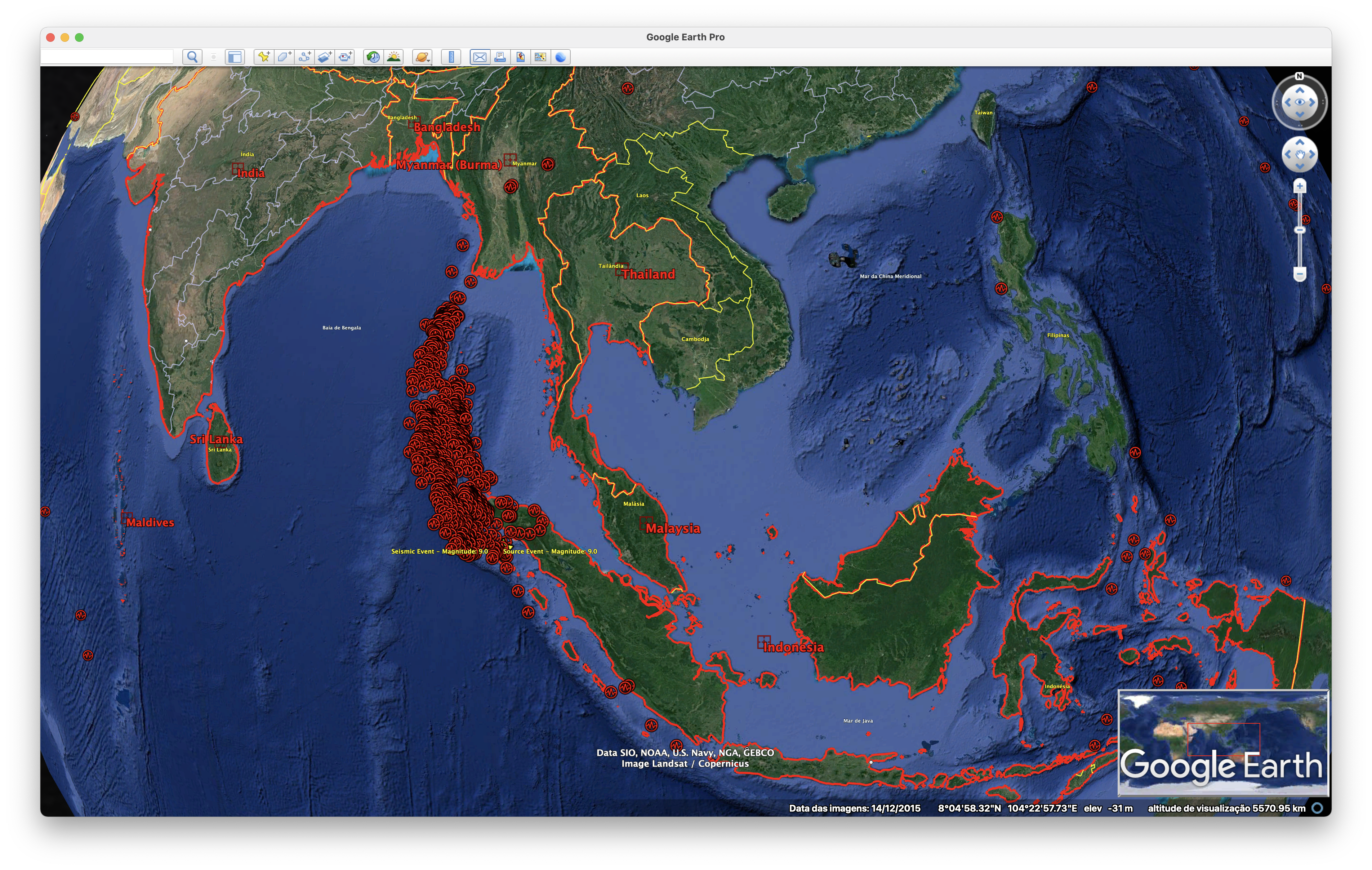
Seismic events are explored using the same file by activating the “Seismic Events” layer. These events are related to tectonic plate boundaries (KMZ available on the drive: limites_placas_tectonicas.kmz) and the different types of boundaries, referring to divergent, convergent, and other types. A connection is made between the tectonic plate boundaries and the plate on which Portugal is located. Students are questioned about the different types of plate boundaries.
The video “240 million years ago to 250 million years in the future” by Chris Scotese, professor in the Department of Earth and Planetary Sciences at Northwestern University (USA), is explored. The video simulates tectonic plate movement from 240 million years ago to 250 million years into the future.
Activity Development
After exploring the KMZ files mentioned, protective measures against the effects of earthquakes are discussed with the students. They are also asked about existing detection methods that could anticipate an event like the one seen in the movie.
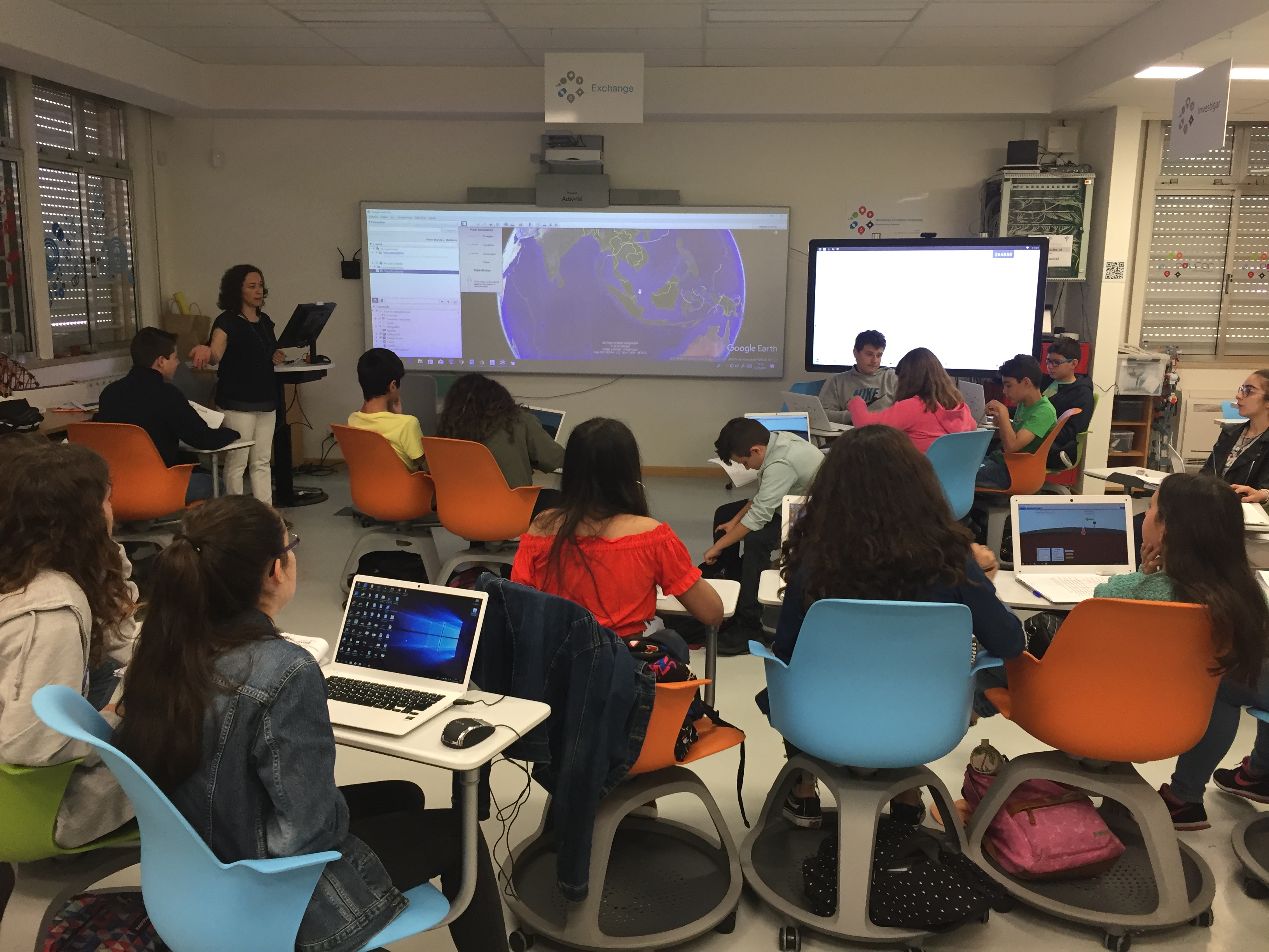
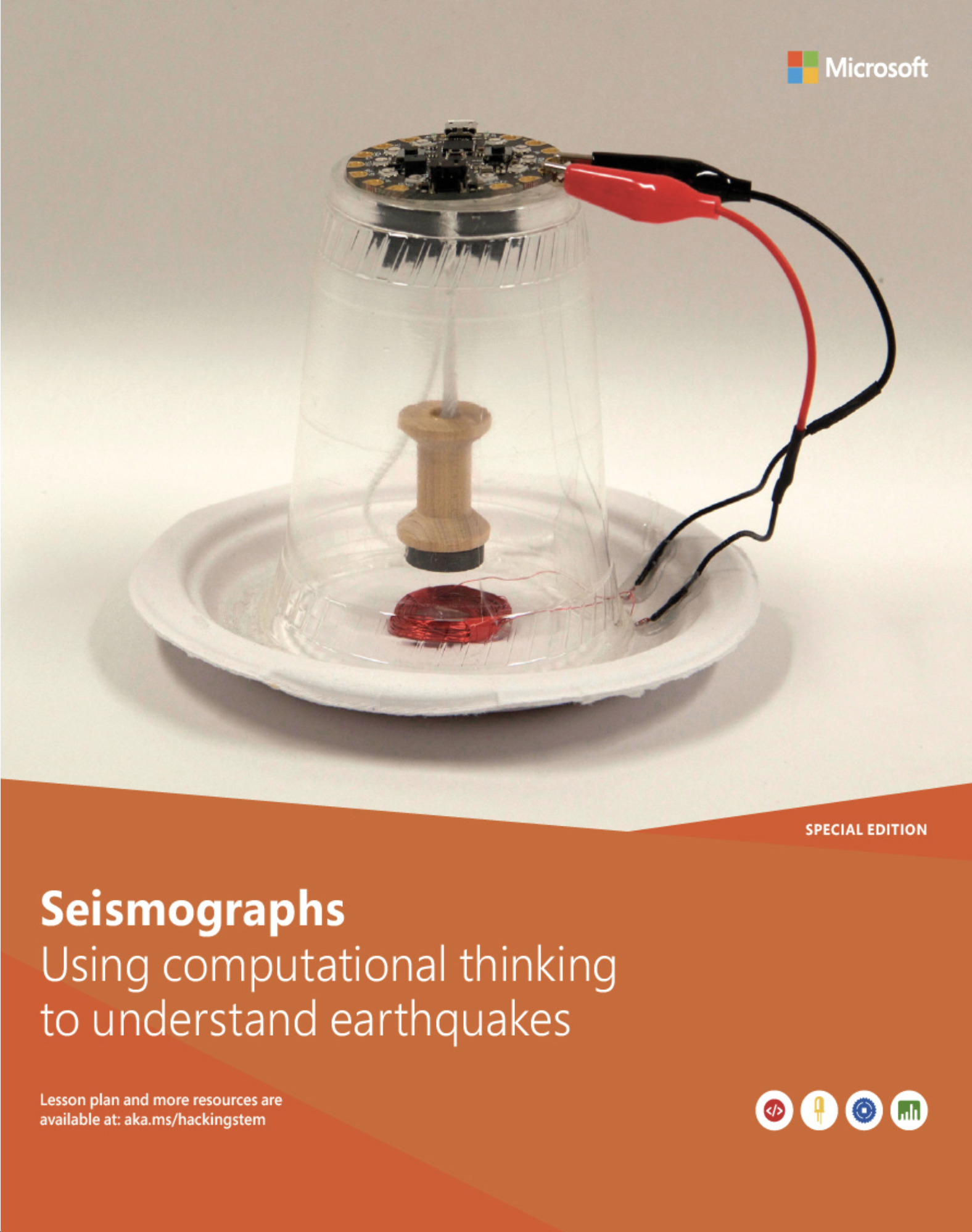
Students are then challenged to build a seismograph in groups, with warnings about the proper use of tools like the hot glue gun (which will be shared among all groups).
The class is divided into groups of 4 to 5 students, the student guide is handed out, and step 1 is projected to analyze the main steps in building a seismograph. Each group receives the following materials:
-
Transparent plastic cup
-
Magnet
-
Crocodile clips
-
Micro:bit and USB cable for computer connection
-
Computer with Office 365 and the Hacking STEM Data Streamer module
-
Cork stopper
-
Plastic plate
-
Copper wire
Teachers assist students in building the seismograph and ask the groups questions about previously discussed topics, such as:
-
What is the function of seismographs?
-
What is the purpose of seismograms?
-
What is the difference between hypocenter and epicenter?
-
What is the relationship between the energy released at the hypocenter and the behavior of seismic waves?
-
What is the difference between magnitude and intensity?
-
What are the consequences of earthquakes?

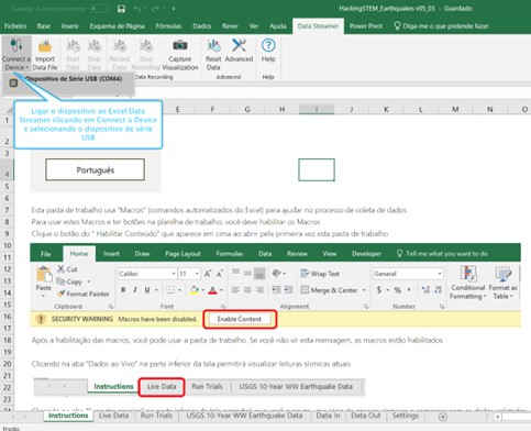
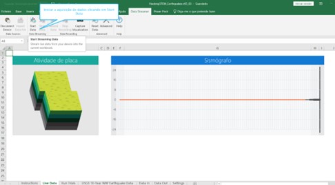
After construction, students are asked to connect the micro:bit with the seismograph to the computer, open Excel with the Data Streamer module, and follow the instructions in the student guide to start collecting data from the seismograph by simulating an earthquake (shaking the plate or table).
Students are then asked to complete task 2 from the student guide.
For task 3, students use the PhET simulation plate-tectonics_pt_BR.jar to explore the density differences between different lithospheric plates, using various tools (density, temperature, and thickness measurements) and examining the consequences of interactions between different types of plate boundaries. The simulation is projected at the front of the classroom, with some features demonstrated, and a student is asked to use the projection to explore the density in a specific location. Questions posed include:
-
In a convergent movement between equal plates, when the density of plate A is greater than that of plate B, what is the expected result? Justify your answer.
-
In a convergent movement between equal plates, when the densities of plates A and B are equal, what is the expected result? Justify your answer.
-
In a convergent movement between a continental crust plate and an oceanic crust plate, what is the expected result? Justify your answer.
Two tablets with the application installed are distributed per group, and students are asked to explore other features and draw conclusions related to material density, using temperature, density, and thickness as factors. The teacher circulates among the groups and questions them about the different outcomes obtained from the simulation variables.
Before students complete task 4 from the guide (on seismic waves), the animation “2004 Sumatra Quake & Tsunami” by the Incorporated Research Institutions for Seismology is shown. The animation is discussed with the students, with questions about P and S waves. Students are asked about the area affected by the earthquake, establishing the relationship between the similarity ratio of figures and the ratio of perimeters/areas.
In task 4, students use Google Earth to measure distances between points:

Activity Conclusion
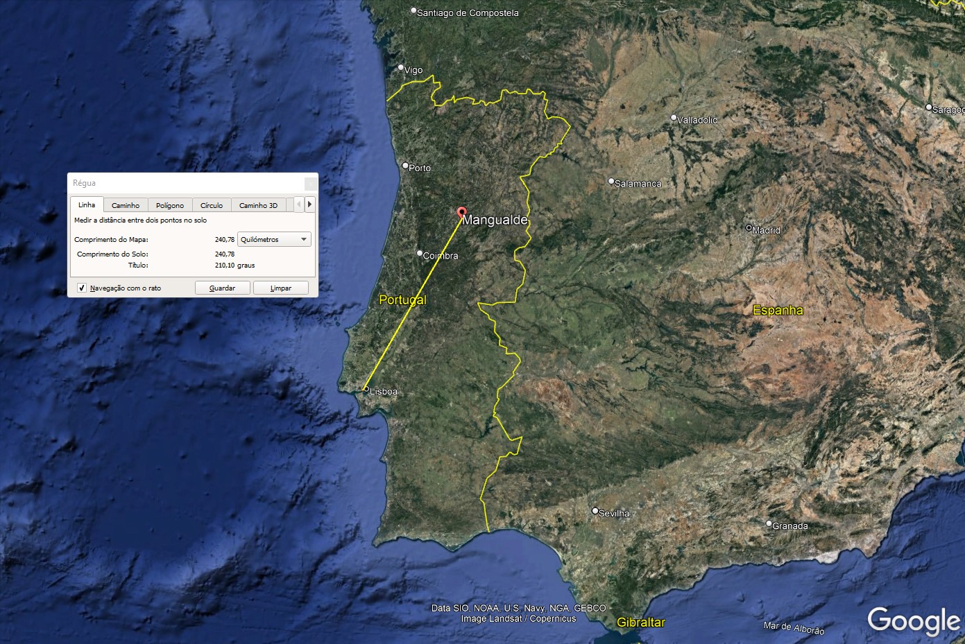
A national context is introduced by creating a hypothetical case from the following question:
“If a magnitude 9 earthquake on the Richter scale occurred in Lisbon, would a resident of Mangualde have time to prepare for its impact there?”
The following data table is presented and discussed.
Students are questioned about the distance from Lisbon to Mangualde and are encouraged to verify it using Google Earth. Based on the analysis of the table and the distance, the initial question is asked again. Students are asked to explain their reasoning.
Essential learnings
Evidence / Student action
- Explicar a distribuição dos sismos e dos vulcões no planeta Terra, tendo em conta os limites das placas tectónicas.
- Exploração do ficheiro KMZ relacionado com o movimento de placas tectónicas - discussão sobre os diferentes fenómenos possíveis de observar.
- Relacionar os fenómenos vulcânicos e sísmicos com os métodos diretos e indiretos e com a sua importância para o conhecimento da estrutura interna da Terra, explicitando os contributos da ciência e da tecnologia para esse conhecimento.
- Em grande grupo, discussão sobre o excerto do filme “O impossível” apresentado, relacionando-o com os factores que originaram o tsunami.
- Compreender o conceito de massa volúmica e efetuar cálculos com base na sua definição.
- Discussão em grupo sobre a(s) simulação(ões) que a aplicação “platetectonics” potencia.
- Identificar e representar semelhanças de figuras no plano, usando material e instrumentos apropriados, incluindo os de tecnologia digital, e utilizá-las em contextos matemáticos e não matemáticos, prevendo e descrevendo os resultados obtidos, incluindo o seu efeito em comprimentos e áreas. Resolver problemas usando ideias geométricas em contextos matemáticos e não matemáticos, concebendo e aplicando estratégias de resolução, incluindo a utilização de tecnologia, e avaliando a plausibilidade dos resultados.
- Resolução da tarefa 4 do Guião do Aluno
IRIS. (s.d.). 2004 Sumatra Quake & Tsunami. Acedido em http://ds.iris.edu/seismon/swaves/index. php?lat=3.31&lon=95.85&depth=30&mag=9.1&title=2004%20Sumatra%20Quake%20%26%20 Tsunami&date=2004-12-26T00:58Z&w_terrain=false&wiki=https%3A%2F%2Fen.wikipedia. org%2Fwiki%2F2004_IndianOcean_earthquake_and_tsunami em 30 de junho de 2022
IRIS. (s.d.). Magnitude explained: Moment magnitude vs Richter Scale. Acedido em https://www.iris.edu/hq/inclass/animation/magnitudes_moment_magnitude_explained em 30 de junho de 2022
Microsoft Hacking STEM. (2022). Use computational thinking to understand earthquakes. Acedido em https://docs.microsoft.com/en-us/learn/educator-center/instructor-materials/use-computational-thinkingunderstand-earthquakes em 30 de junho de 2022
PhET. (2022). Placas tectônicas. Acedido em https://phet.colorado.edu/pt_BR/simulations/plate-tectonics em 30 de junho de 2022
Scotese, C. (2015). 240 million years ago to 250 million years in the future. Acedido em https://www. youtube.com/watch?v=uLahVJNnoZ4 em 30 de junho de 2022
In 2004, a catastrophe occurred in Southeast Asia: an earthquake followed by a tsunami.
As a result of the tragedy, hundreds of thousands of people and many other living beings died throughout the region. After the fateful event, the United Nations began developing technological mechanisms to anticipate the occurrence of earthquakes in that area.
In this activity, you will take on the role of a scientist and develop a device that simulates the occurrence of earthquakes, analyzes data, and calculates the magnitude of a hypothetical earthquake.
In addition, you will study why the Sumatra earthquake occurred and calculate the propagation areas of seismic waves.
Task 1 – Building a Seismograph
Phase I – Research and construction of a seismograph
To build a seismograph in a group, go to Microsoft Learn – Hacking STEM, na atividade Use computational thinking to understand earthquakes.
After downloading the document Build Instructions, you will find all the steps to follow for building a seismograph.
NOTE: Carry out all the steps carefully, paying special attention when handling the materials, especially the hot glue gun!
Phase II – Earthquake simulation and data collection
The seismograph is now assembled! You now need to connect it to Excel Data Streamer to collect data. To do this, follow these steps:
-
Connect the micro:bit to the laptop via USB;
-
In Excel, under the Data Streamer tab, click on Connect a device and select the USB serial device;
-
In the Live Data Excel sheet, start data collection by clicking the Start Data button.
Task 2 – Data obtained from the seismograph
The following image results from the simulation you performed on your seismographs. The data obtained can be interpreted as follows:
2.1 Looking at the image beside, explain how the magnitude of an earthquake is obtained.
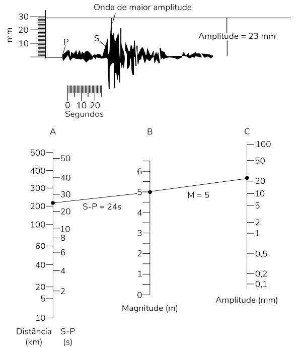
2.2 Based on the analysis of the previous image and knowing that the next image relates to the Sumatra earthquake, what is the magnitude of this earthquake on the Richter scale?

Task 3 – After exploring the app “plate-tectonics, fill in the following table with the symbols “” and “=”. In the last column, describe the behavior observed
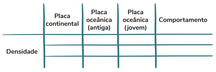
3.1 Explain why subduction of oceanic plates occurs at convergent boundaries with continental plates.
3.2 Explain why mountain formation occurs at convergent boundaries between continental plates.
3.3 Identify the type of tectonic plate boundary that occurs near the Sumatra region.
Task 4 – P and S Waves
The following image shows the epicenter (E) of the Sumatra earthquake and other points reached by the resulting S and P waves. Carefully observe the lines representing the S and P waves, respectively.
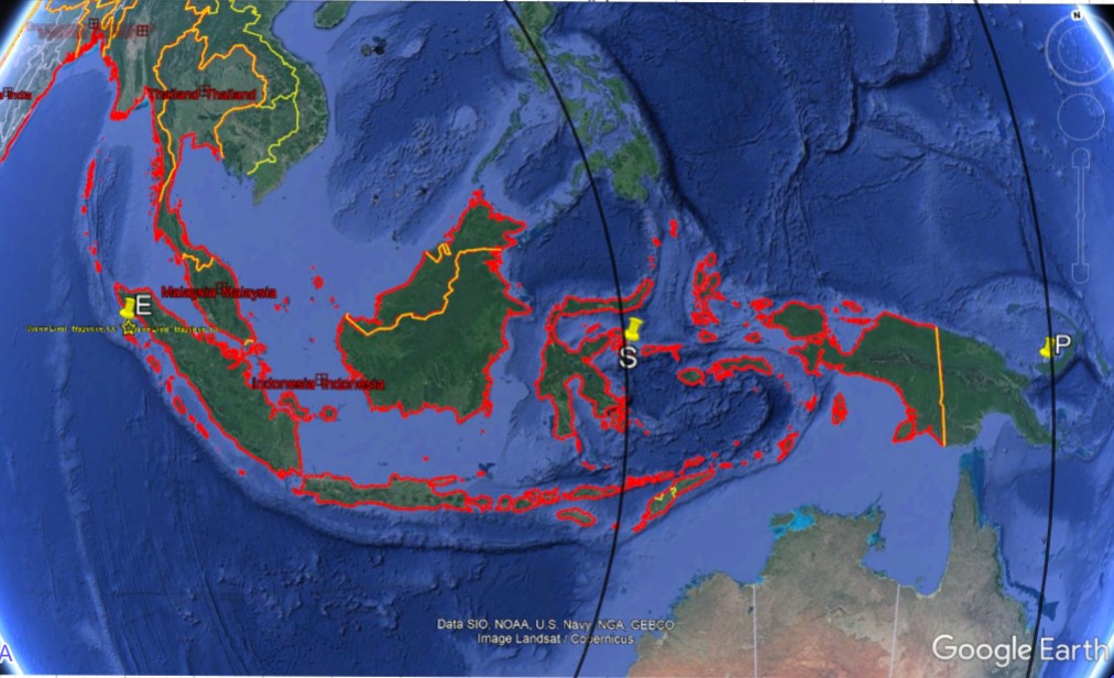
Given that [ES] = 3000 km and [EP] = 6000 km, answer the following questions:
4.1 Are the partially represented circles centered at point E similar?
4.2 Calculate the ratio between the radius of the larger circle and the smaller circle.
4.3 Calculate the ratio between the perimeters of the circles and the ratio between their radii.
4.4 Calculate the ratio between the areas of the circles centered at E and the ratio between their radii.
4.5 Investigate whether there is a relationship between these two ratios and the similarity ratio of the radii.
4.6 Establish that relationship.
Task 5 – Imagine that an earthquake similar to the one in Sumatra occurred in a region very close to mainland Portugal, near Lisbon. Observe the following image carefully.

5.1 Is there a tectonic plate boundary near the Lisbon region? Refer to the National Geographic article from May 6, 2019:
A tectonic plate may have peeled apart – and that could shrink the Atlantic Ocean para responder a esta questão.
5.2 Would it be possible for an earthquake similar to the Sumatra one to occur in that location? Why?
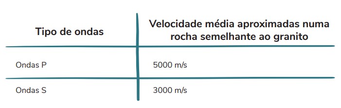
5.3 Calculate how long it would take for the P and S seismic waves to reach Mangualde, assuming that:
-
P waves travel at 5000 m/s
-
S waves travel at 3000 m/s
5.4 Would people in Mangualde be able to protect themselves from the earthquake before the seismic waves arrived? Explain your answer.
5.5 In what situation could this earthquake trigger a tsunami?